
Climate Change in the Kurdistan Region and Iraq; Deforestation, Fires and Burning of Trees
20-08-2023
Introduction
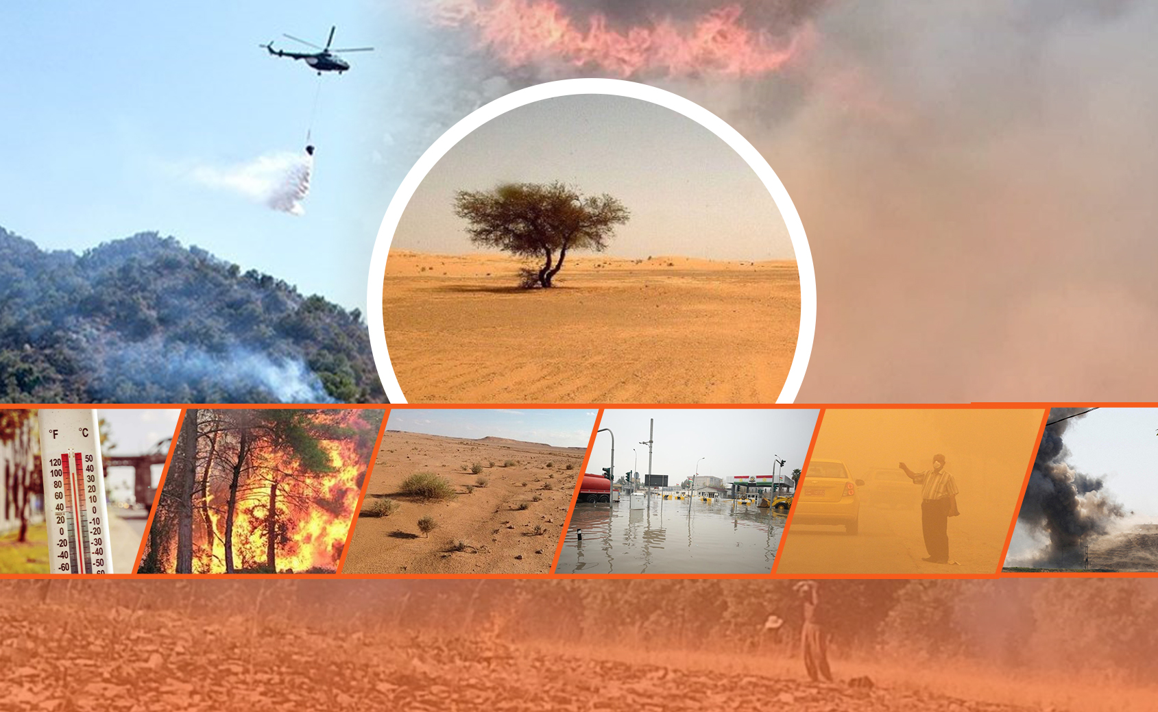
The destruction of trees and green cover in Iraq and the Kurdistan Region is such that 100 square kilometers of land become desert every year, while 40% of the land itself is desert. This desertification, destruction of greenery and fires, in addition to its long-term consequences, will reduce agricultural land in Iraq from 12.2% to 8.3%, increase water evaporation and destruction of wells, rivers and waterways.
According to GFW[1], Iraq will lose 137 hectares[1] of wooded land between 2000 and 2022, 22 hectares due to fire alone and the remaining 115 hectares due to various reasons. The year with the highest loss of trees and green space was in 2003 when 7 hectares of wooded land were destroyed by fire.
[1] The local authority in Iraq and the Kurdistan Region has not recognized the data from GFW. So, it may be different due to using different methods for data collection.
Meanwhile, according to a scientific study in 2000, Iraq had 9,800 square kilometers of desertified land, but after 14 years has reached more than 14,400 square kilometers, while in the past decade, deforestation, drying of forests, fires and rising temperatures The heat has increased and entered a new phase.
In fact, the loss of greenery is directly related to high temperatures, so these days Iraqi cities record the highest temperatures in the world, while according to data from the European Union's climate change agency C3S last month was the hottest month ever recorded The month was 0.72 degrees Celsius warmer on average from 1991-2020 and 1.5 degrees Celsius warmer on average from 1850-1 If we compare the temperatures in Iraq between the two periods, they are twice as high as in the world.
In the second part of this series of assessments, we present a position on environmental changes such as deforestation, greenery, number of fires, continued impact of war and desertification at the provincial level in Iraq and the Kurdistan Region.
Destruction of trees and Green Cover in Iraq and the Kurdistan Region
Iraq has 28,600 hectares of wooded land, but only 9,460 hectares of wooded land has increased in the past two decades, or 0.1 percent of the world's total. See graph 1 on stable and available trees and forests throughout Iraq.
Graph 1: Stable and achievable green area trees at Iraqi level / hectare
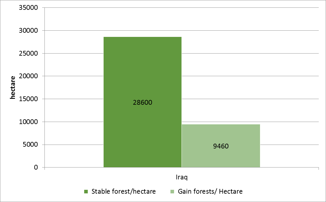
Note, these data are for the period between 2000-2020, with more changes in the past three years
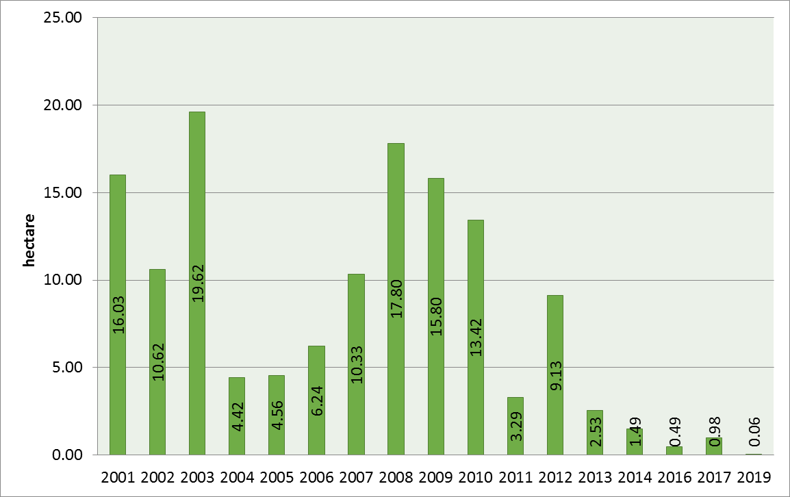
According to GFW data, between 2001 and 2019, 0.78% or 137 hectares of trees and wooded land in Iraq were destroyed, but despite the increase in the number of fires, but year by year, especially from 2008 to last year has come.
Graph 2: Tree destruction in Iraq between 2001 -2019 in hectares
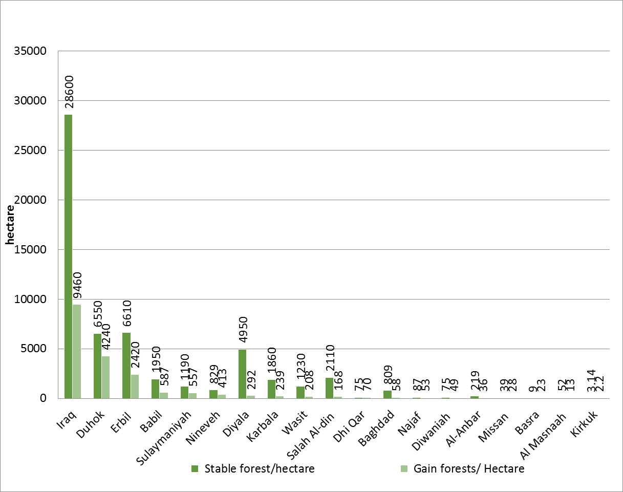
Also, at the level of Iraqi and Kurdistan provinces in terms of stable and available trees and forests Erbil province is the best and Kirkuk province is the worst, followed by Duhok province, while Kirkuk has only 3.14 hectares of trees and 2.2 hectares of trees and greenery, which is the lowest in Iraq and the Kurdistan Region.
Graph 3: Stable and achievable tree and greenery land cover in Iraqi provinces
Fire Alerts in Iraqi and Kurdistan Region Provinces
According to the VIIRS data, the fire season starts in late February and lasts for 40 weeks. Between August 8, 2022 and August 7, 2023, 18,442 fires were recorded in all Iraqi provinces, an increase compared to previous years.
Between 2001 and 2022, about 22 hectares of wooded land will be burned and another 115 hectares will be destroyed for other reasons in Iraq. The highest fire destruction was in 2003, when 7 hectares were destroyed.
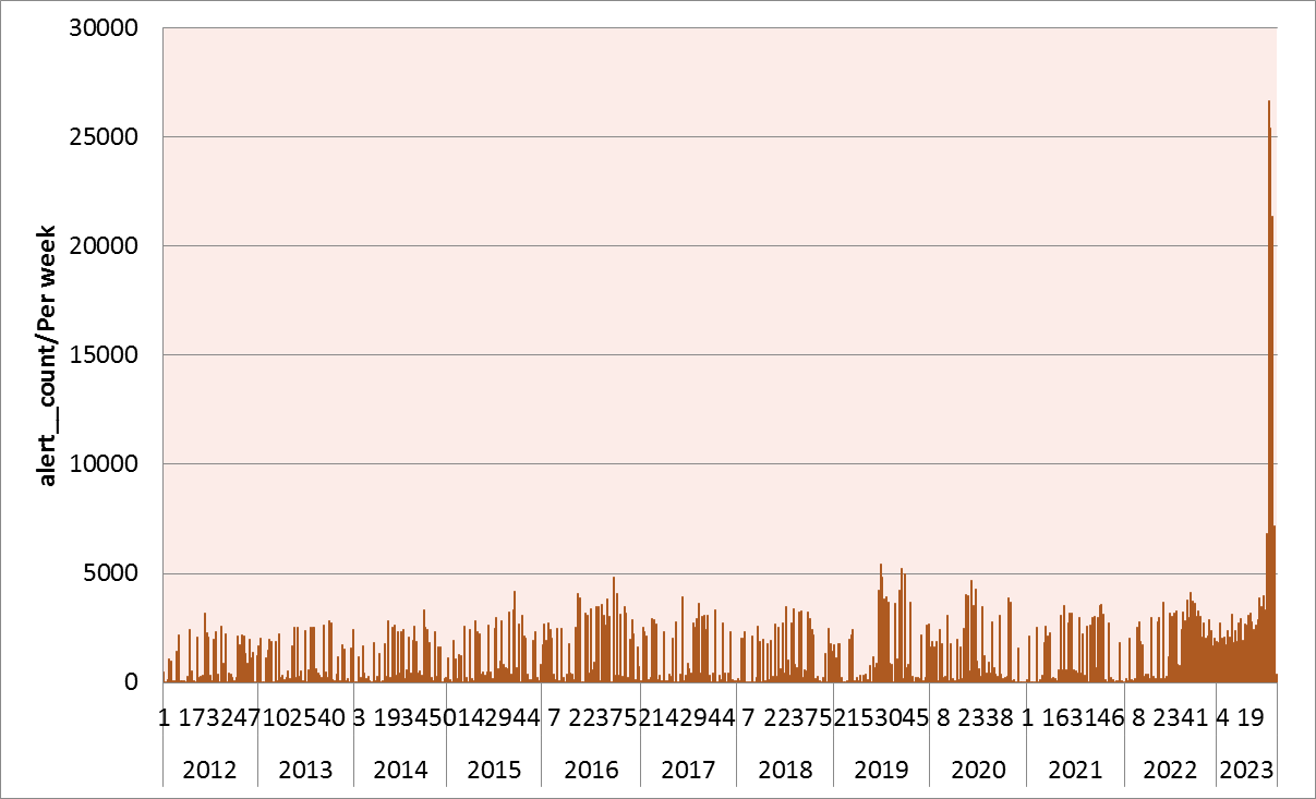
This summer, especially from late June to the first week of August, the number of fires in Iraq has doubled, so that in 2012 to 2022 did not reach more than 5,000 weekly fires, but this year has exceeded more than 25,000 fires in Iraq.
Graph 4: Number of fire incidents by week of the year from 2012 to 2023 in Iraq
Burning of trees, shrubs in the Kurdistan Region
There have been weekly incidents of burning trees and forests in the past two months, which is spreading rapidly, not only in the Kurdistan Region, but also in most countries in particular In countries with dense forests, fires are on the rise due to rising temperatures and the consequences of climate change.
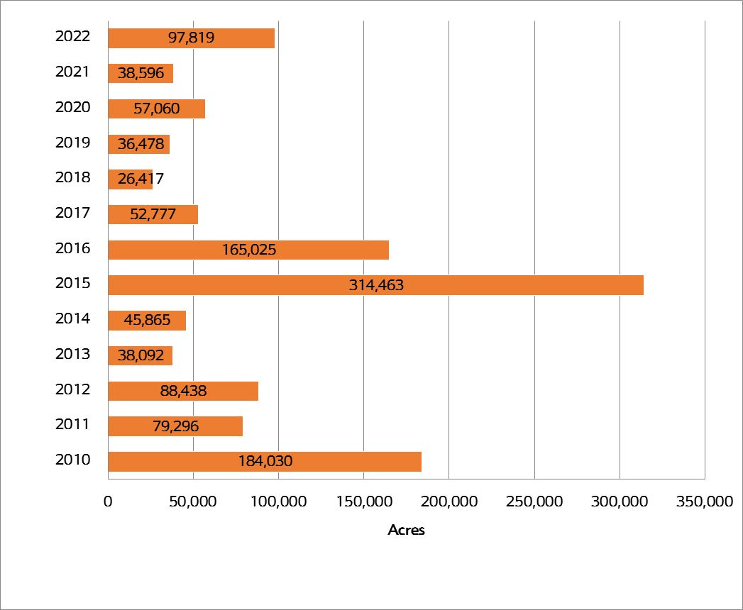
According to the statistics of the Forestry Directorate of the Ministry of Agriculture in 2015, the largest area of trees, land covered with trees, Cotton was burned, amounting to 314,000 acres that year.
According to the available data, the least number of forest fires in the Kurdistan Region were natural causes, but the factors that caused the destruction of trees and greenery during the past decade were primarily military and humanitarian activities, most notably bombing and military attacks According to a report by PACS, 49,568 acres of green area have been burned in the mountainous areas alone due to Turkish bombings and the fight against the PKK 659 acres of this area are in naturally protected areas. From May to September 2020 alone, 298,750 acres of forests were burned[2].
At the domestic level, fires and lack of awareness, the presence of coal mines and logging in winter are the human factors behind the burning and destruction of forests in the Kurdistan Region. In the fire incident in northern Erbil’s mountain in the Balakyati region in Choman district alone (August 16, 2023), 6,000 trees and about 4,000 acres of forests were burned and destroyed. According to the data of the Forestry Directorate of the Ministry of Agriculture and Water Resources, the most fires and burning of trees, shrubs and trees in Sulaimani province, as shown in the second graph.
Graph 5: Burning of trees, shrubs and trees in the Kurdistan Region from 2010 to 2022
Conclusion
In March this year, at a climate conference in Basra, the Iraqi prime minister announced a plan to plant 5 million trees, but according to the expenditures of the Iraqi Ministry of Finance for the first five months of this year, no dinars have been spent on investment projects!
Climate change and the loss of trees and forests in the Kurdistan Region and forests in central and southern Iraq, which make up an important part of this territory, are already having an impact and nearly seven million Iraqis are suffering from the consequences.
The changes are not only natural, but the role of humans and the continued wars and conflicts, especially in mountainous areas, has caused the decline of trees and green areas covered with trees. According to statistics, the green area in the Kurdistan Region has decreased from 23.46% to 12.44% during the two decades (1999-2018).
Fires in July reached the highest number in a decade, with more than 18,000 fires recorded by satellites across Iraq, not only with short-term consequences such as burning trees, destroying old trees and biodiversity and displacing kiwi livestock In the long run, it will create a new phenomenon that will have a profound impact on subsequent years in terms of rainfall and warming of the region, called La Nina, which has occurred in Australia in recent years.
Finally, if efforts are not put into action and conflicts are not reduced and continue, we will say goodbye to the green natural areas in Iraq and the Kurdistan Region more quickly. In the next and third part of this series, we will take a look at air pollution and carbon dioxide emissions in Iraq and its consequences.
Sources:
Othman, A.A., Al-Saady, Y.I., Shihab, A.T., Al-Maamar, A.F. (2020). The Aeolian Sand Dunes in Iraq: A New Insight. In: Al-Quraishi, A., Negm, A. (eds) Environmental Remote Sensing and GIS in Iraq. Springer Water. Springer, Cham. https://doi.org/10.1007/978-3-030-21344-2_12
Hansen, M. C., P. V. Potapov, R. Moore, M. Hancher, S. A. Turubanova, A. Tyukavina, D. Thau, S. V. Stehman, S. J. Goetz, T. R. Loveland, A. Kommareddy, A. Egorov, L. Chini, C. O. Justice, and J. R. G. Townshend. 2013. “High-Resolution Global Maps of 21st-Century Forest Cover Change.” Science 342 (15 November): 850–53. Data available on-line from: http://earthenginepartners.appspot.com/science-2013-global-forest.
[1] One hectare is equal to 10,000 square meters or 2,471 acres in the measurement system
[2] https://paxforpeace.nl/media/download/pax-environment-conflict-alert-iraq.pdf